Connect With Your Community!
Connect With Your Community!
Democrats wanted a competitive western district. Republicans wanted a simple split. The districting commission chair wanted compromise. This is how it all shook out.
HELENA - With a final vote Friday, Montana's Districting and Apportionment Commission made it official: The state has a new congressional map, political lines drawn to define how Montanans are represented in the U.S. House through the 2030 election.
While the boundaries could still be subject to a court challenge, the vote represents the likely culmination of a monthslong districting process that kicked into gear when detailed 2020 census results were published in August, triggering a once-a-decade effort to recalibrate Montana's political boundaries. The proceedings drew hundreds of publicly submitted proposals, days of verbal testimony at hearings in the state Capitol and thousands of written comments filed by residents across the state.
The districting commission is composed of two Republicans, two Democrats and a tiebreaker chair appointed by the Montana Supreme Court. On a split vote, with chair Maylinn Smith siding with the GOP members over Democratic opposition, the body ultimately backed a proposal that in some respects mirrors the east-west map Montana used in the 1980s, before the state lost its second congressional seat following the 1990 census. It was only last year, in the 2020 count, that Montana added enough new residents to escape the ranks of low-population states with only a single U.S. House representative.
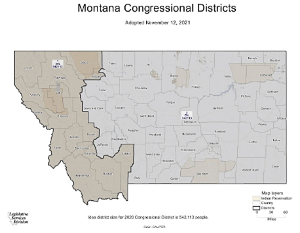
Montana's new U.S. House Districts.
As did the 1980 map, the 2020 map carves a western district from Montana's stretch of the Rocky Mountains, more or less leaving the plains to the east. The new map assigns Missoula, Butte, Kalispell and Bozeman, along with the Flathead and Blackfeet Indian Reservations, to its western district. Great Falls, Helena, Lewistown and Billings, along with the five other Indian Reservations in the state, are in the east. The new map keeps 55 of Montana's 56 counties intact, splitting Pondera County north of Great Falls.
WHAT DEMOCRATS WANTED
That arrangement wasn't necessarily a foregone conclusion. While Republican commissioners Jeff Essmann and Dan Stusek consistently backed variations on the east-west split adjusted for western Montana's significant post-1980 population growth, Democratic commissioners Kendra Miller and Joe Lamson floated several other configurations that grouped southwestern Montana into one district while leaving Kalispell and eastern Montana in the other. At various points, commissioners examined maps that would have split some combination of Cascade, Flathead, Gallatin or Lewis and Clark counties.
Democrats also pushed, with partial success, for a map where their candidates would have a reasonable shot at edging out Republicans at the ballot box in one of the two new districts.
While Montana has elected two Democrats, Sen. Jon Tester and former Gov. Steve Bullock, to statewide office since 2014, the state as a whole has trended redder in recent elections, and hasn't elected a Democratic congressman since Pat Williams in 1994.
Left-leaning Montanas told the districting commission the state's current GOP tilt means elections are often decided, in effect, in Republican primaries, encouraging candidates to strike extreme policy positions to appeal to their party base, and discouraging them from putting much effort into trying to win over less conservative voters. Democrats have in recent years routinely criticized Republicans in Montana's congressional delegation for rarely holding town hall-style events that expose them to questions from unsympathetic constituents. In 2018, Sen. Steve Daines pushed back on that critique in an interview with Yellowstone Public Radio, saying town halls "tend to be big protests versus good, civil discourse."
Competitiveness advocates told the commission that drawing a western district with enough Democratic voters to put candidates on more equal footing would empower comparatively moderate candidates and provide Montanans across the political spectrum with more effective representation in Washington, D.C.
"Politics in both our country and our state is full of divisiveness, anger, and outrage - and much of this is fueled by a lack of competitive Congressional seats, as politicians cater to the angry voices at the extreme fringes for fear of being 'primaried out,'" Huson resident Julie Chapman wrote in a written comment filed with the commission Nov. 7.
Chapman also said she doesn't feel well represented by the state's current Republican officeholders.
"I do not feel that my voice is heard, or that my concerns (about climate change, inequality, and so much more) matter," she wrote.
'GET AFTER THE VOTES'
Montana's current political geography is such that the simplest way to divide the state's population into two congressional districts - a nearly straight north-south boundary - produces two districts with a Republican lean similar to the state as a whole. That map, which GOP districting commissioners introduced as their first proposal in October, would have divided the growing Democratic stronghold of Bozeman from left-leaning voters in Missoula.
Many Republicans commenters supported that map throughout the process, urging commissioners to take a 'politics-blind' approach to drawing lines. Drawing a map with likely political outcomes in mind puts an unfair thumb on the scale, they argued - giving politicians a chance to pick their voters rather than the other way around.
"Get out there, put the feet on the ground and get after the votes. That's competitive. That's the competitive idea of this country and our state," Great Falls resident George Wardell told the commission Oct. 19. "Our people in this state are smart enough to know issues and know the candidate they want to choose."
Some conservatives also cited a state law that tries to bar the districting commission from considering political data such as voter affiliations or prior election results. That statute, originally enacted in 2003, was amended by the Republican-controlled Montana Legislature this year with language designed to give the commission specific directions for how to draw congressional districts.
At an Oct. 30 hearing, Rep. Derek Skees, R-Kalispell, was one of dozens of Republicans who stepped to the podium during public comment to argue that law should prevent the commission from considering concerns about competitiveness.
Rep. Derek Skees, R-Kalispell, addresses the districting commission Oct. 30. The markers on the sign he holds read "San Fransoola" and "Bozeangeles." Credit: Montana Public Affairs Network
"If you continue down this road it will lead to a lawsuit and a delay and a failure in your jobs," Skees said.
"If you have to break the law, please do it with CP-10 or CP-12," he added, referring to two maps that had been proposed by Republican commissioners.
It's unclear whether the no-consideration-for-political-data clause would hold up in court if tested, given that the framers of Montana's Constitution granted districting authority to an independent commission with the express intent of limiting a partisan Legislature's ability to influence the district-drawing process.
According to a Montana Law Review article co-authored by Jim Regnier, the former state Supreme Court justice who chaired the 2010 districting commission, the 2003 statute cited by present-day Republicans was adopted because legislators didn't like the legislative map drawn by the commission after the 2000 census. After the Legislature passed two bills trying to preempt the commission's authority, a court ruled in favor of the commission, formally nullifying part of the newly created statute. While the remaining pieces of the statute haven't been subject to a legal challenge, Regnier wrote that they've been "largely ignored" by subsequent commissions.
The current districting commission adopted guidelines this summer that allowed it to consider political competitiveness alongside mandatory districting criteria such as population equality, Voting Rights Act compliance, and geographic compactness. As the body debated the merits of different mapping proposals, both Republican and Democratic commissioners cited third-party partisan ranking statistics and compiled breakdowns showing how past candidates would have performed inside the proposed new boundaries.
Smith, an attorney, said Nov. 4 that her read of the state Constitution and applicable case law persuaded her the commission is on solid legal ground, despite its critics' complaints.
"I believe that the criteria we've adopted does satisfy the directives from those documents," she said.
THE ADVOCATES
Beyond the Legislature's efforts to shape the districting process, the commission was lobbied extensively by citizens and politically active organizations aligned with Republican and Democratic partisans.
The state Republican Party, for example, named a districting committee of its own to advocate for GOP priorities, and also used its email list to rally member support for its preferred maps.
"Democrats are coming in at full force to try to take this new seat and keep the speaker's gavel in Nancy Pelosi's hands," read one email, sent on Oct. 22 and signed by party chairman Don "K" Kaltschmidt. "If we can't stop them now, we will have to live under the Democratic regime for years on end."
Montana Republicans also organized a brief rally before the Oct. 30 meeting. Several dozen attendees arrived on a fire-truck-red tour bus that, according to an organizing email circulated by the Western Montana Liberty Coalition and entered into the commission record, was scheduled to depart from the Red Lion Hotel in Kalispell that morning shortly after 4 a.m.
"Please help STOP THE STEAL of elections in Montana by making your voice heard!" that email read, in part, adding that attendees should be prepared "for the 'ride of your life.'"
Lauralee O'Neil, a Kalispell resident, said in an interview that she and her husband, John, had chartered the bus, attracting about 40 riders. They had requested a red vehicle, she said, "to let people know we are conservatives."
O'Neil said the cost had been covered in part by donations, but declined to say who donated.
On the left side of the partisan spectrum, advocates for Democratic proposals included organized labor groups that testified against Republican-suggested maps that placed Helena and Butte in different districts by arguing they would dilute the power of those communities' union presence.
"Allow working people who advocate together to stay together in these maps," Montana Federation of Public Employees president Amanda Curtis said at a Nov. 4 hearing.
A group called Fair Maps Montana also advocated for adopting competitive districts, a position that aligned closely with proposals from Democratic commissioners. The group doesn't disclose its backers on its website, where it says its purpose is "to mobilize and train every day Montanans to have a say in the community districting process."
Montana Women Vote program director Ella Smith said in an interview this week that Fair Maps Montana is a coalition of four progressive nonprofits: Montana Women Vote, Forward Montana, Western Native Voice, and Montana Conservation Voters. The groups, she said, have pooled resources to advocate for maps they think would ensure their members' concerns are more reliably heard in the political process.
"It is our belief that competitiveness strongly encourages candidates to actually spend time in their communities and get to know their constituents on a more meaningful level," she said.
Smith said the Fair Maps effort had spent some money on mailing postcards, but primarily worked via digital channels. The group ran Facebook ads and its website included a page discussing what it saw as the pros and cons of different maps. Montana Women Vote spent between $5,000 and $6,000 on the effort, most of that staff time, she said.
Montana Commissioner of Political Practicers Jeff Mangan said this week that political spending intended to influence the districting commission isn't necessarily covered by the state's disclosure laws, which apply to spending on political candidacies, ballot measure campaigns and some paid efforts to lobby the Montana Legislature.
"There's not a statutory obligation reason for them to report to us," Mangan said.
THE FINAL CONTENDERS
As the districting process entered its home stretch over the last month, with the commission holding six meetings in four weeks, debate coalesced around a trio of maps: CP-12, the GOP proposal that was ultimately adopted, and two Democratic alternatives that sought a more competitive district by grouping a bigger slice of the state's blue voters in the west.
Two congressional map proposals forwarded by Democratic commissioners.
One of those maps, CP-11, placed Helena and Livingston in the western district, splitting Whitefish from Kalispell and Columbia Falls to balance the district's population.
A second, CP-13, kept Flathead intact in the west, but divided Lewis and Clark and Gallatin counties to place the liberal urban cores of Helena and Bozeman in the western district while allocating those cities' northern suburbs to the east.
Republican commissioners argued that their CP-12 proposal represents a reasonable adjustment from the historic districts.
"I believe that this is a map that respects commonalities of interest that Montana has traditionally had, reflecting a genuine difference of east-west divide that matters for so many different reasons," Stusek said Nov. 9.
"I think we've got a good district. It will require energy on the part of both parties to elect someone and retain them. And it will require candidates that listen," Essmann said.
Democrats, though, maintained that other proposals would better address their concerns.
Miller acknowledged Nov. 9 that the adopted proposal meets the legal requirements for new districts. But, she said, it "unduly favors one party," in contrast to one of the commission's stated goals.
Miller cited a third-party analysis commissioned by the Native American Rights Fund, in which University of New Mexico political scientist Loren Collingwood examined the three final proposals using election results from statewide races in 2016, 2018 and 2020.
"Although exceptional Democratic candidates can and have won under Map 12 (e.g., Jon Tester), Republican candidates are much more likely to win here and win easily," Collingwood wrote.
Native advocacy groups and some tribal leaders had lobbied to include as many tribal communities as possible in a competitive district, arguing that those political dynamics would force candidates to pay more attention to the concerns of Native voters. In a letter submitted with the NARF analysis, Blackfeet Tribal Chairman Timothy Davis wrote, "...we do not believe Map CP 12 is competitive enough to actually incentivize politicians to engage with us."
That's a missed opportunity for the state, Miller argued.
"With two districts instead of one, the majority party shouldn't be handed both districts," she said. "We had plans before us that could have been adopted with a competitive district."
An analysis by Montana Free Press indicates that three Democrats who have run unsuccessfully for statewide office since 2014 received enough votes to have won the newly adopted CP-12 map's western district: Kathleen Williams in her 2018 bid for U.S. House, Rob Quist in his House bid during the 2017 special election, and Melissa Romano in her 2016 bid for Superintendent of Public Instruction.
Neither of the two Democrats who have won statewide races in that period, Sen. Jon Tester in 2018 and Gov. Steve Bullock in 2016, received enough votes in those elections to win the adopted eastern district. Those conclusions align with similar analyses done by others, including Collingwood, GOP districting commissioners and the Fair Maps Montana group.
Who could have won the west?
Some recent elections would have shaken out differently if votes had been counted in Montana's new congressional districts. A look at which recent candidates for the U.S. House would and wouldn't have won with the newly adopted maps.
Even before the new congressional districts took shape, candidates from both parties have begun to line up to run for office, particularly in the western district. Montana's incumbent Congressman, Matt Rosendale of Glendive, will likely seek re-election in the eastern district. One Democrat, Jack Ballard of Red Lodge, has announced a challenge to him.
Three Republicans from the western district have also announced U.S. House bids: former Montana U.S. Rep. Ryan Zinke of Whitefish, Al Olszewski of Kalispell and Mary Todd of Kalispell. They're joined in the race by four announced Democrats: Monica Tranel of Missoula, Cora Neumann of Bozeman, Tom Winter of Missoula and Laurie Bishop of Livingston. While Livingston was placed in the eastern district, Bishop's campaign said this week that she intends to run in the west. (The U.S. Constitution requires U.S. Representatives to live in the state they represent, but not necessarily in their district.)
Montana's 2022 primary election is scheduled for June 7 and the general election is set for Nov. 8. With its congressional work completed, the districting commission will now turn its attention to redrawing the boundaries used to elect the Montana Legislature.
THE TIEBREAKER
Chairperson Smith had long voiced hope that she could guide the commission's partisan members to a consensus. Nov. 4, however, she acknowledged that the commission was gridlocked and voted with Republican members to advance the CP-12 proposal.
She held firm on that decision at the commission's next meeting, Nov. 9, as Democratic commenters railed against the proposal, and again as the commission took its final vote Nov. 12 to pass the proposal along to the Montana secretary of state.
"I'm a parent. I have been a judge. I fully understand that people often don't like my decisions, and I live with that," she said Nov. 9.
Smith, a tribal law expert who spent decades as a University of Montana Law professor, saw her appointment to the commission by the Montana Supreme Court last year met with pointed criticism from Republicans, who questioned her commitment to impartiality on the basis of campaign contributions she had made to Democratic candidates. A statement from the state Republican Party accused the court of "allowing Democratic insiders to Chair the redistricting process."
Ultimately, though, Smith bucked that suspicion.
While she accepted Democrats' arguments about the value of crafting a map with a competitive district, she declined to take that idea as far as the commission's Democratic members wanted.
She decided against voting for their preferred proposal, the CP-11 map, where the prospect of splitting Whitefish from Kalispell had drawn howls of outrage from Flathead Republicans. Instead, she threw her tie-breaking vote behind the CP-12 proposal.
The political data she had seen, Smith said, indicated that both of those maps would have produced the same outcomes in Montana's last five congressional elections, leading her to conclude that the CP-12 proposal was competitive enough - and that it was the option that is most fair to the state as a whole.
"To me, with the right person there, you can have a competitive district," she said Nov. 4.
She was reluctant to endorse a map that divided Pondera, a small county, she said, but noted that the split had been endorsed by its county commissioners.
"I, too, want extraordinary candidates," Smith added Nov. 9. "That's how you get good government, is you have extraordinary people out there who can advocate. I think both sides are capable of putting forth extraordinary candidates."
Editor's Note: This article was originally published by Montana Free Press. For more information, please visit http://www.montanafreepress.org.